 Introduction
1
What he called barbarity became the core of the notion of genocide, but vandalism did not make it into the Genocide Convention. It is, however, reflected in the 1954 Hague Convention for the Protection of Cultural Property in the Event of Armed Conflict, which became effective in 1956.Although recent developments in international criminal law have incorporated the destruction of cultural heritage into the understanding of genocide – the UN Tribunal for ex-Yugoslavia noted, in one decision, that "where there is physical or biological destruction there are often simultaneous attacks on the cultural and religious property and symbols of the targeted group as well, attacks which may legitimately be considered as evidence of an intent to physically destroy the group"—it was only recently on in September 2016 that such attacks themselves were found to constitute a war crime.
2
Judges at the International Criminal Court in the Hague sentenced Ahmad al-Faqi al-Mahdi to serve nine years in prison for his role in demolishing historic Muslim shrines in Timbuktu. The case marks the first time an international court has convicted a defendant for the destruction of cultural heritage as a war crime. In this trial the burden of proof did not rely on the prosecution since al-Mahdi confessed to this crime, and so in the future, it might remain difficult to try this erasure of culture in a court of law. In the midst of civil war in Syria we have created a map to assess damage to the built fabric of Aleppo (Halab), one of the oldest continuously inhabited cities in the world, using satellite images. What is urban damage? A process, a fact, a crime, an image? A trace of the human?
2 seconds
Below are three commercially-available high-resolution satellite images that we are using as primary resources in studying Aleppo. These snapshots register a location in space, 250 square kilometers of Aleppo, represented as millions of pixels each measuring 50cm x 50cm. And they each bear a time stamp, down to fragments of a second in accuracy: (May 1, 2012, September 3, 2015 at 08:27:47.281250 GMT, and March 23, 2016 at 08:26:14.541829 GMT). Destruction becomes visible over time.2 days
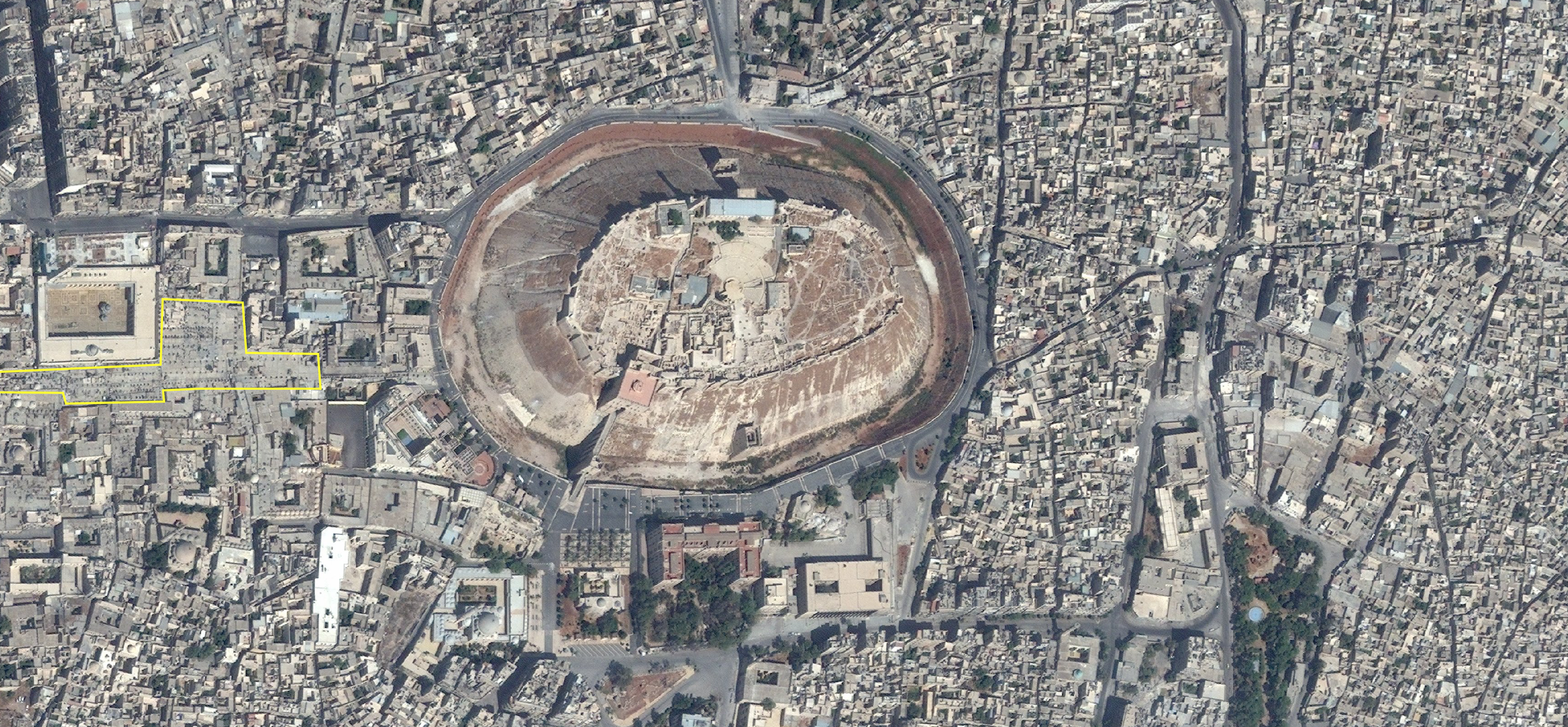
Satellite image captured on September 27, 2012 (© 2012 DigitalGlobe, Inc.), the Souq al Madina, Aleppo’s hundred-year-old covered market that caught fire two days after the image was taken, is outlined in yellow on the image.
Beginning on September 29, 2012, two days after the first satellite image was taken, the six hundred-year-old covered market, or souq, in the center of the city burned. In the same days of fighting, the historic passport office overlooking the Citadel was bombed by Syrian government forces.
3
The Ancient City of Aleppo, including the Citadel, was added to UNESCO’s World Heritage List in 1986, as "an exceptional reflection of the social, cultural and economic aspects of what was once one of the richest cities of all humanity."4
On September 30, as it was burning, the Director-General of UNESCO called attention to its destruction: "the human suffering caused by this situation is already extreme. That the fighting is now destroying cultural heritage that bears witness to the country’s millenary history -- valued and admired the world over -- makes it even more tragic." She reminded the Syrian government that it was bound by the Hague Convention "to do its utmost to safeguard this heritage from the ravages of war."5
2 years
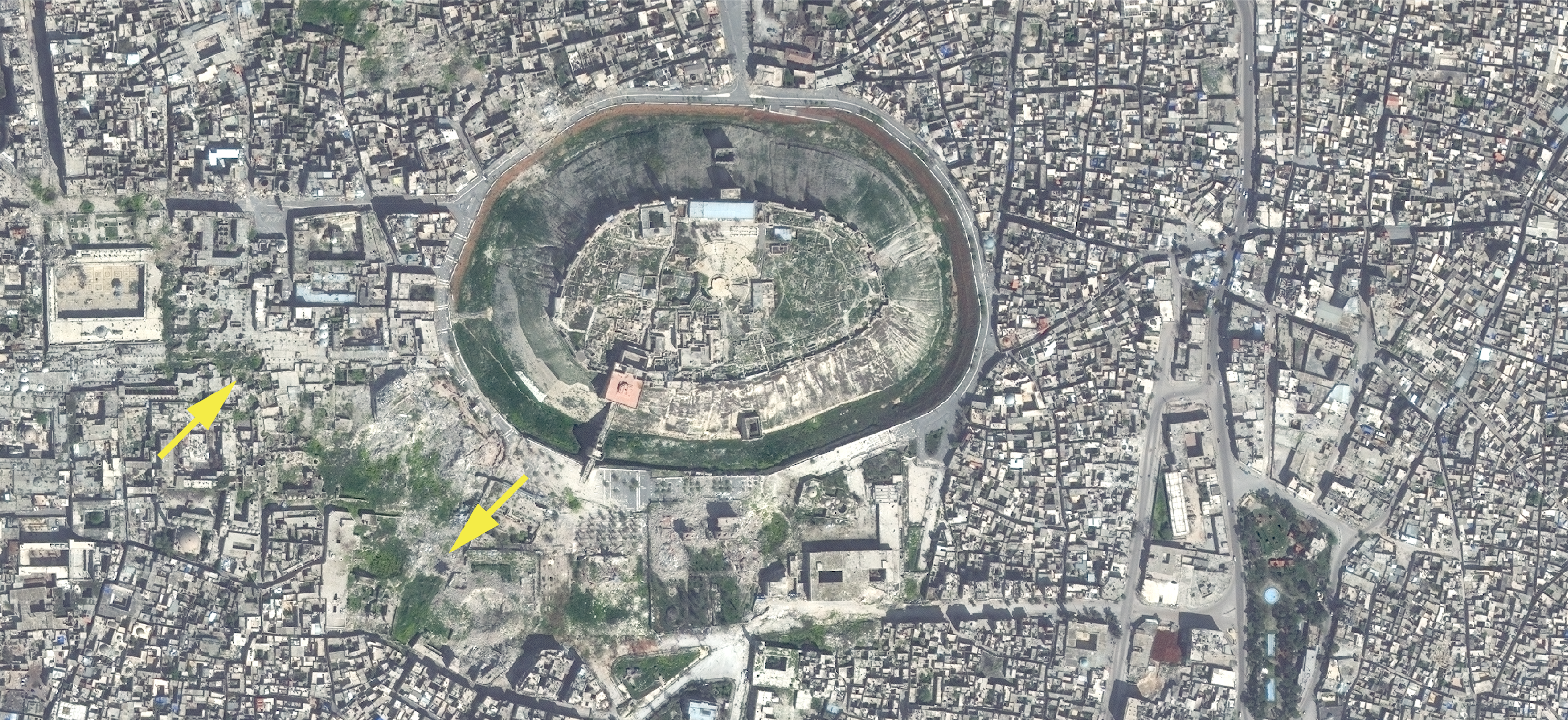
Green growth of vegetation that, over the last two years has come to cover damaged sites is visible in a satellite image from March 23, 2016.
Over the five years of civil war in Syria, many buildings and neighborhoods in Aleppo have been destroyed, extending far beyond the souq and the Old City. Craters mark the building, streets, and parks – and a conflict ecology has become visible in the overhead images. The three satellite images tell some of the stories of this ongoing erasure and its varied aftermaths – deaths, departures, and the haunting green growth of vegetation that has come to cover (and identify) the damaged spaces. It too is an outcome of the war, a sign of neglect and inattention – some purposeful, and some inadvertent.
200 years
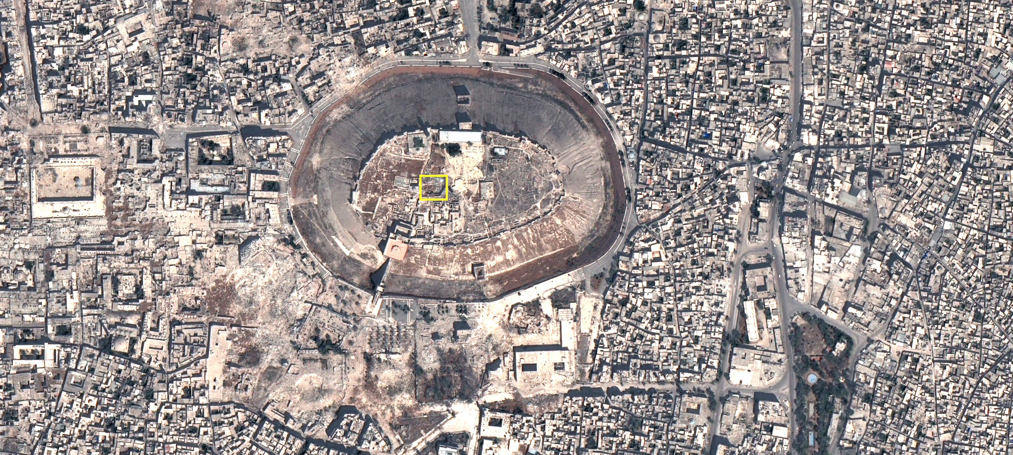
The archeological site of this 5000 year old temple to the Storm God Hadad is outlined on a satellite image from September 3, 2015.
There have been other wars in Aleppo, other moments in which artifacts have been destroyed, damaged, or disappeared. At the end of the 19th century, a short stone column covered in hieroglyphs and a carving of the storm god Adda or Hadad was excavated from the palace of Nabuchadnezzar II in Bablyon. The column, or Stele, was discovered to have originated in Aleppo. It was likely taken to Babylon in the 9th century BCE, after the Assyrians took control of Aleppo and its surrounding regions. It now resides in the Istanbul Archeology Museum.
6
2000 years
The displaced column of the Storm God is between three and five thousand years old. It is very similar in form to carved blocks found in an archaeological site on top of Aleppo’s Citadel. The Citadel is nearly a thousand years old, and it has long been a witness to destruction and creation. It was built on top of a high point in the city, and it marks the center of the city both visually and symbolically. But archaeologists believe that the site of the Citadel was the central point of Aleppo long before the 11th century. As the UNESCO World Heritage citation notes: "With evidence of past occupation by civilizations dating back to the 10th century B.C., the citadel contains the remains of mosques, palace and bath buildings."7
200 000 years
The early emergence of cities and civilizations in Syria is in part due to the climate of the Fertile Crescent region over the last 200,000 years. Cities were designed around agricultural lands where wheat and grains were cultivated in irrigated fields. And the urban/agricultural frontier continues to prove decisive for the fate of the area. Between 2006 and 2011, the region experienced its "most severe drought in the instrumental record," and the very fertility that had sustained Aleppo for so long turned against it. Scholars have linked the drought both to anthropogenic climate change and to the governance and agricultural policies of the Assad regime. The crop failures it caused displaced farmers from their land, fueled migration into cities, and no doubt played some role in the civic uprisings against the regime that began in 2011.8
Aleppo: 200,000 years to two seconds. Multiple erasures, displacements, creation, and growth are embedded in pixels, revealing a city shaped and structured by destruction. At least some of which are crimes of war which must be stopped.
Exhibit: Scale 1:1000
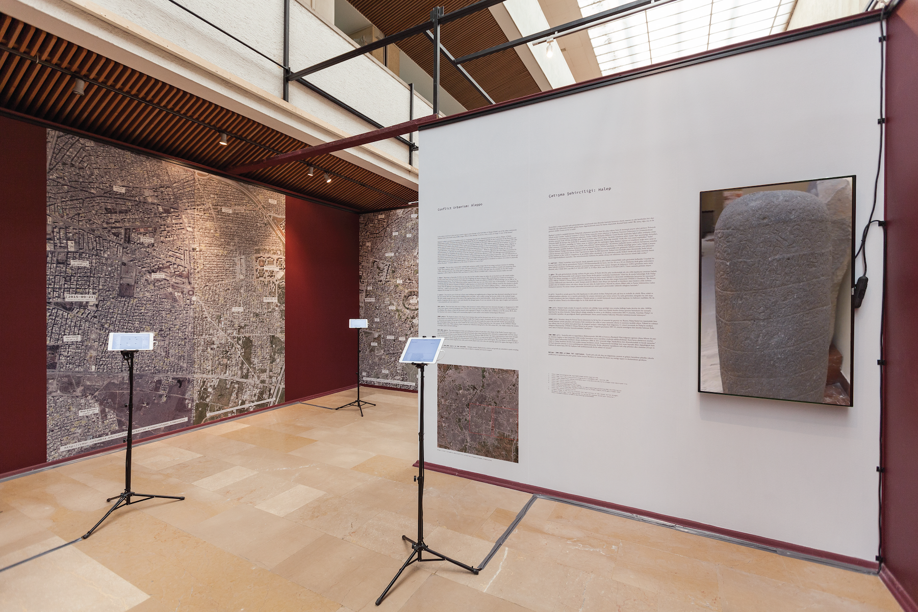
Conflict Urbanism: Aleppo exhibit at the 2016 Istanbul Design Biennale, Are We Human? in October 2016. Photo credit: Sahir Ugur Eren
We exhibited this work on Aleppo in the 2016 Istanbul Design Biennale, which is titled “Are we Human?” and which presents projects that stretch “from the last 2 seconds to the last 200,000 years.” This sliding scale is essential for understanding Aleppo, where everything ancient is at risk of destruction in the blink of an eye. The pace of the war is so relentless that even the latest satellite imagery, the latest news report, is effectively out of date by the time we see it or read it.
We are displaying two zooms from high-resolution satellite images of Aleppo at the scale of 1:1000. For every one unit of space in the gallery, the corresponding space in Aleppo is one thousand times larger.
Satellite imagery of Aleppo from September 3, 2015 (© CNES_2015, distribution AIRBUS DS, France) and March 23, 2016 (© 2016 DigitalGlobe, Inc.)
On this interactive map, the frames show you the two zooms we selected for display. When you click and zoom on this map the highest zoom scale is that same 1:1000.
Zoom, turn on UNOSAT layer, as well as Satellite 2015 layer. Then switch to Satellite layer 2016 and search for difference. You will be guided in looking for damage by the marked points of the UNOSAT dataset, highlighting damaged buildings from 2012 until July 2015. The UNOSAT annotations are incomplete for the 2016 image, so you might notice unmarked damage, particularly the imprint of months of continual airstrikes by the Russian and Syrian governments against the rebel-held half of the city.
Return to Case Studies
Case Study Team:
Laura Kurgan, Grga Basic, Dare Brawley