 Introduction
Introduction
Conflict Urbanism: Aleppo is a project in two stages.First, we have built an open-source, interactive, layered map of Aleppo, at the neighborhood scale. Users can navigate the city, with the aid of high resolution satellite imagery from before and during the current civil war, and explore geo-located data about cultural sites, neighborhoods, and urban damage.
Second, the map is a platform for storytelling with data. We are inviting collaborators and students to bring new perspectives and analyses into the map to broaden our understanding of what's happening in Aleppo. Case studies will document and narrate urban damage — at the infrastructural, neighborhood, building, social, and cultural scales — and will be added to the website over time.
We invite ideas and propositions, and hope to build on the data we have compiled here to create an active archive of the memory of destruction in Aleppo through investigation and interpretation, up close and from a distance.
Urban Damage
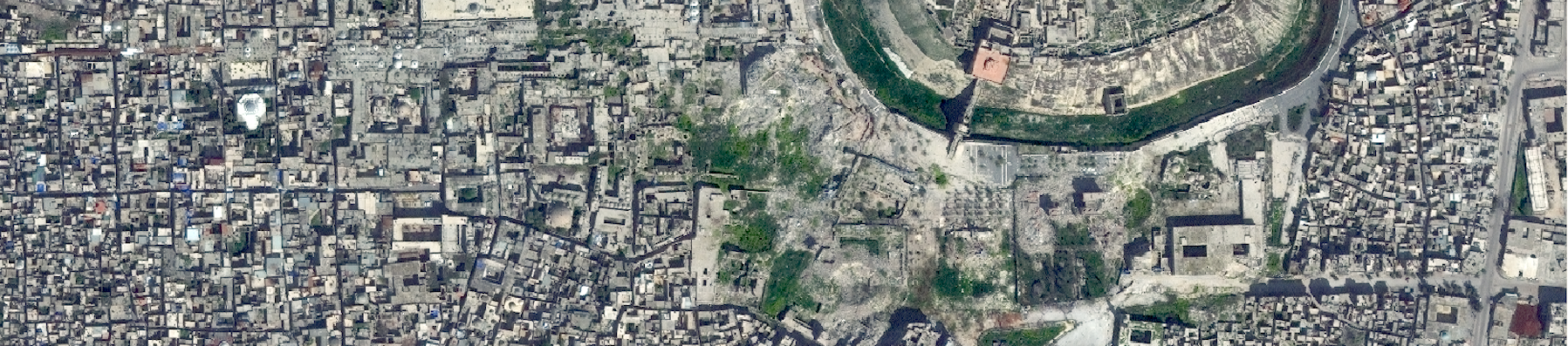
Since 2012, the people of Aleppo have been exposed to catastrophic violence. Many thousands have been injured, died, or fled. Millions of people have been displaced. Our work focuses on what has happened in their city, the largest city in Syria before the war and one of the oldest cities in the world, and what might happen to it in the future. Aleppo has suffered extensive physical damage: to its symbolic centre, the Citadel; its surrounding heritage sites, which mark ancient empires, diverse religions, and multiple cultures and trade routes; and to its eastern and southern neighborhoods which housed many ‘informal’ neighborhoods before the war. The city has been remapped by conflict. Both the old city and the neighborhoods to its east and south have evolved into opposition territory during the war, and come under siege. But beyond the military logic, Aleppo’s cultural and urban history, as well as its cultural memory and identity, appears to have been directly targeted.“The Destruction of Memory”
Raphael Lemkin’s conception of vandalism serves as a motivating rationale and a theoretical frame for our work here. The Polish-Jewish lawyer Lemkin coined the term 'genocide' during World War II. The category was codified in the Convention on the Prevention and Punishment of the Crime of Genocide, which was adopted by the UN General Assembly in December 1948 and entered into force in January 1951 after twenty states had ratified it. But, as we learn in Robert Bevan’s book, The Destruction of Memory, already in 1933 Lemkin had described genocide in terms of two interlinked concepts: barbarity and vandalism. He understood barbarity primarily as "acts of extermination" targeting "ethnic, religious or social collectivities," and vandalism as the "systematic and organized destruction of the art and cultural heritage."1
What he called barbarity became the core of the notion of genocide, but vandalism did not make it into the Convention.Vandalism is, however, reflected in the 1954 Hague Convention for the Protection of Cultural Property in the Event of Armed Conflict, which became effective in 1956. And although recent developments in international criminal law have incorporated the destruction of cultural heritage into the understanding of genocide – the UN Tribunal for ex-Yugoslavia noted, in one decision, that "where there is physical or biological destruction there are often simultaneous attacks on the cultural and religious property and symbols of the targeted group as well, attacks which may legitimately be considered as evidence of an intent to physically destroy the group" – it was only recently that such attacks themselves were found to constitute a war crime. In September 2016,
2
judges at the International Criminal Court in the Hague sentenced Ahmad al-Faqi al-Mahdi to serve nine years in prison for his role in demolishing historic Muslim shrines in Timbuktu. The case marks the first time an international court has convicted a defendant for the destruction of cultural heritage as a war crime.The Memory of Destruction
Although trials for crimes of war against people and buildings might be far in the future for Syria, evidence is being collected by multiple organizations, including the Violations Documentation Center, as well as local residents, journalists, and activists. Hundreds of thousands of videos, photographs, and accounts of destruction and violence have been uploaded and distributed on social media platforms. But for what tribunal?One of the ways of challenging the destruction of memory, the physical destruction of the urban fabric and its tangible and intangible heritage, is the preservation of the multiple forms of what might be called a memory of destruction.
Over the five years of civil war in Syria, many buildings and neighborhoods in Aleppo have been destroyed. Craters and rubble mark the building, streets, and parks that have come under attack. The four satellite images layered into our map tell some of the stories of this ongoing erasure and its varied aftermaths – deaths, departures, and the reorganization of the urban landscape. You can see its traces not only in the images of destruction but also in the green growth of vegetation, that has come to cover (and identify) the damaged spaces, and the water from that broken pipes that fills the craters.
It is our hope that this aerial imagery, and the investigations developed to ask questions with it, will can be linked with social media and other perspectives from the ground, and contribute to an ongoing preservation of the memory of destruction in Aleppo.
Investigation from a Distance
Different approaches to conflict and struggle require different temporalities, rhythms, and modes of representation. Journalists work on specific stories in the moment or over time; human rights work involves patient documentation and urgent calls to action; humanitarian work necessitates emergency responses as well as long-term commitments. Practitioners of all these forms of responses, though, often worry about the lack of opportunity to reflect, to analyze critically what they are doing, to appreciate the larger frames and forces that affect the situations in which they are trying to report and intervene. We hope that this project will allow both the on going documentation and registration of the struggle of Aleppo and its people -- and provide a space for reflection and critical understanding.It' s for this reason that we made a map that can collect, assemble, and curate data resources from multiple perspectives, and evolve over time. The map is a resource for looking at Aleppo, as well a prototype of investigative and analytic methods for other cities in conflict.
Each case study deploys a variety of ways of embedding our map into a narrative or analytic story, and each time adds to it through a unique story window. The following list will evolve:
Patterns of Damage: Aleppo
Using UNOSAT damage data, some former planning documents produced by GIZ are overlaid onto a 2015 image of Aleppo to investigate patterns of disproportionate damage in informal parts of Aleppo.Remote Sensing Urban Damage
Using free low resolution Landsat imagery, in collaboration with a remote sensing analyst we have made "change maps" in Aleppo for every two weeks of the war, as a means of navigating the city and the news, looking for evidence of damage on high resolution imagery.Spatializing the Youtube War in Aleppo
Our team has analyzed five youtube channels for their spatial patterns as well as creating a browsable interface for viewing the video by neighborhood.Conflict Urbanism: Aleppo Seminar
In the Spring of 2016, Columbia Students used the map as a resource and starting point for research about the Civil War. The results of their work is documented here.Return to Case Studies